
The ExCiteS research group and Mapping for Change, teamed up with Dr Catherine Holloway and Sarah Nicholson, Accessibility Engineering researchers at UCL, Ross Akin, an accessibility designer and users of the Queen Elizabeth’s Foundation Mobility Centre for a day long workshop.
The aim of the study was to develop tools and methodologies for mobility impaired users to collect data on the topic of accessibility that would then facilitate the creation of more accurate and usable accessibility maps.
Who are the users?
The wheelchair users involved in this study have limited mobility skills. However, all users had prior ICT experience, including the use of apps, and did not have limited literacy skills. Some of the participants have weakened fine motor skills that may restrict their use of a typical app interface.
During a workshop the participants identified appropriate icons and structure to turn Sapelli into an accessibility reporting tool. Download the project here: Wheelchair Accessibility v3.0
Project
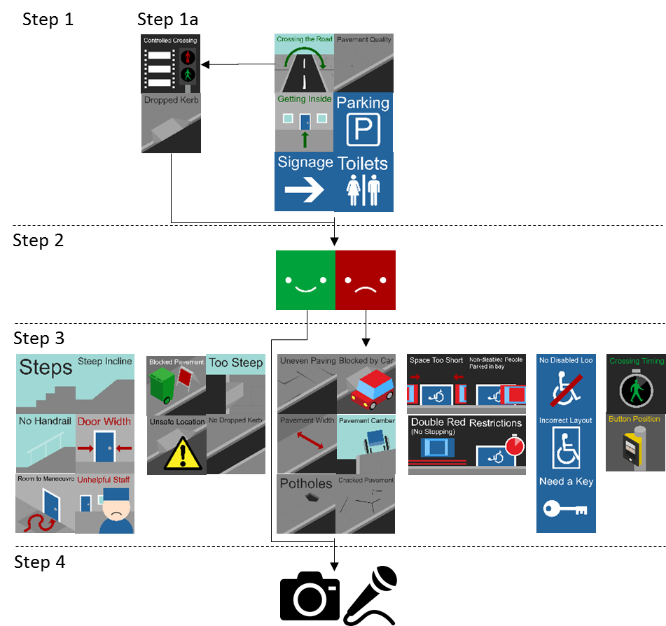
Step 1 of the decision tree requires the user to select an initial icon representing the category (for road crossings there is a sub-category in step 1a to select either dropped curbs or controlled crossings), step 2 to select the positive indicator (green ‘smiley’ icon) and then at step 4 capture a photograph or audio recording. Barriers, or negative accessibility point of interest, require an additional step which allows the users to more precisely select the type of barrier, for example when selecting ‘pavement quality’ at step 1 a user may then select ‘cracked paving’ as the specific quality issue at step 3.
Project XML
Here you can find the code for this project. Comments have been included in italics in order to guide you through the XML file.
|
1 2 3 4 5 6 7 8 9 10 11 12 13 14 15 16 17 18 19 20 21 22 23 24 25 26 27 28 29 30 31 32 33 34 35 36 37 38 39 40 41 42 43 44 45 46 47 48 49 50 51 52 53 54 55 56 57 58 59 60 61 62 63 64 65 66 67 68 69 70 71 72 73 74 75 76 77 78 79 80 81 82 83 84 85 86 87 88 89 90 91 92 93 94 95 96 97 98 99 100 101 102 103 104 105 106 107 108 109 110 111 112 113 114 115 116 117 118 119 120 121 122 123 124 125 126 127 128 129 130 131 132 133 134 135 136 137 138 139 140 141 |
<?xml version="1.0" encoding="UTF-8"?> <!-- The unique Sapelli Project ID number, the name of the project, default language (British English), and version number are declared here. --> <SapelliCollectorProject id="201506" name="ArcMap" defaultLanguage="en-GB" version="3.0"> <!-- This Project only contains one Form element which is given the ID name "ArcMap". This Form element contains all the Choice, Media and Location fields below. A shortcutImage has been included, the image "Shortcut.png" will be used to represent the Shortcut file of this project on the home screen of a user's phone. storeEndTime has been enabled to store the time at which a user saves and exits this Form. --> <Form name="ArcMap" shortcutImage="Shortcut.png" storeEndTime="true" > <!-- This first Choice field is the 'root' of the decision tree and contains all the other Choice elements within the tree. Similar to the Form element above it, it is provided with an ID name. The Choices contained within this element will be displayed within two columns and three rows on the device's screen. The Choices (displayed as images) are: "Crossing the Road", "Cracked Pavement", "Getting Inside", "Parking", "Signage" and "Toilets". --> <Choice id="Situation" rows="3" cols="2"> <!-- This Choice set contains all the possible Choice elements if the user were to click the "Crossing the Road" image on the screen. Clicking on this option will display two further Choices: "Controlled Crossing" or "Dropped Kerb". These Choices will be displayed within one column and two rows on the device's screen. A background colour has been set to be displayed behind the Choice image. --> <Choice backgroundColor="#848484" img="CrossingTheRoad.svg" rows="2" cols="1"> <!-- This Choice set contains all the possible Choice elements if the user were to click the "Controlled Crossing" option on the screen. Clicking on this option will display two further Choices: "Good" or "Bad". --> <Choice backgroundColor="#272727" img="ControlledCrosing.svg"> <!-- The "Good" and "Bad" Choice images have values. The value represents the data that is recorded if the user were to click that option. --> <Choice backgroundColor="#00A33B" value="Positive" img="Good.svg" /> <!-- Clicking on the "Bad" Choice image will display two further Choices: "Timing" and "Button Position". Each of these Choices has a value. The value represents the data that is recorded if the user were to click that option. --> <Choice backgroundColor="#AC0000" value="Negative" img="Bad.svg" rows="2" cols="1"> <Choice backgroundColor="#272727" value="Timing" img="Timing.svg"/> <Choice backgroundColor="#565656" value="Button Position" img="ButtonPosition.svg"/> <!-- The Choice element which contains the "Bad" Choice set is closed. --> </Choice> <!-- The Choice element which contains the "Controlled Crossing" Choice set is closed. --> </Choice> <!-- This Choice set contains all the possible Choice elements if the user were to click the "Dropped Kerb" option on the screen after clicking the "Crossing the Road" option. --> <Choice backgroundColor="#272727" img="DroppedKerb.svg"> <Choice backgroundColor="#00A33B" img="Good.svg" /> <!-- Clicking on the "Bad" Choice image will display four further Choices: "Blocked By Car", "Too steep", "Unsafe Location" and "No Dropped Kerb". Each of these Choices has a value. The value represents the data that is recorded if the user were to click that option. --> <Choice backgroundColor="#AC0000" img="Bad.svg" rows="2" cols="2"> <Choice backgroundColor="#4A4A4A" value="Blocked By Car" img="BlockedByCar.svg"/> <Choice backgroundColor="#272727" value="Too steep" img="TooSteep.svg"/> <Choice backgroundColor="#464646" value="Unsafe Location" img="UnsafeLocation.svg"/> <Choice backgroundColor="#848484" value="No Dropped Kerb" img="NoDroppedKerb.svg"/> <!-- The Choice element which contains the "Bad" Choice set is closed. --> </Choice> <!-- The Choice element which contains the "Dropped Kerb" Choice set is closed. --> </Choice> <!-- The Choice element which contains the "Crossing the Road" Choice set is closed. --> </Choice> <!-- This Choice set contains all the possible Choice elements if the user were to click the "Cracked Pavement" image on the screen. Clicking on this option will display two further Choices: "Good" or "Bad". --> <Choice backgroundColor="#979797" img="CrackedPavement.svg" rows="2" cols="1"> <Choice backgroundColor="#00A33B" img="Good.svg" /> <!-- Clicking on the "Bad" Choice image will display six further Choices: "Uneven Pavement", "Blocked By Car", "Pavement Width", "Pavement Camber", "Potholes" and "Cracked Pavement". Each of these Choices has a value. The value represents the data that is recorded if the user were to click that option. --> <Choice backgroundColor="#AC0000" img="Bad.svg" rows="3" cols="2" > <Choice backgroundColor="#272727" value="Uneven Pavement" img="UnevenPaving.svg"/> <Choice backgroundColor="#4A4A4A" value="Blocked By Car" img="BlockedByCar.svg"/> <Choice backgroundColor="#272727" value="Pavement Width" img="PavementWidth.svg"/> <Choice backgroundColor="#848484" value="Pavement Camber" img="PavementCamber.svg"/> <Choice backgroundColor="#272727" value="Potholes" img="Potholes.svg"/> <Choice backgroundColor="#272727" value="Cracked Pavement" img="CrackedPavement.svg"/> <!-- The Choice element which contains the "Bad" Choice set is closed. --> </Choice> <!-- The Choice element which contains the "Cracked Pavement" Choice set is closed. --> </Choice> <!-- This Choice set contains all the possible Choice elements if the user were to click the "Getting Inside" image on the screen. Clicking on this option will display two further Choices: "Good" or "Bad". --> <Choice backgroundColor="#979797" img="GettingInside.svg" rows="2" cols="1"> <Choice backgroundColor="#00A33B" img="Good.svg" /> <!-- Clicking on the "Bad" Choice image will display six further Choices: "Steps", "Steep Incline", "No Handrail", "Door Width", "Room to Manoeuvre" and "Unhelpful Staff". Each of these Choices has a value. The value represents the data that is recorded if the user were to click that option. --> <Choice backgroundColor="#AC0000" img="Bad.svg" rows="3" cols="2" > <Choice backgroundColor="#848484" value="Steps" img="Steps.svg"/> <Choice backgroundColor="#848484" value="Steep Incline" img="SteepIncline.svg"/> <Choice backgroundColor="#848484" value="No Hand Rail" img="NoHandrail.svg"/> <Choice backgroundColor="#979797" value="Door Width" img="DoorWidth.svg"/> <Choice backgroundColor="#979797" value="Room To Manoeuvre" img="RoomToManoeuvre.svg"/> <Choice backgroundColor="#979797" value="Unhelpful Staff" img="UnhelpfulStaff.svg"/> <!-- The Choice element which contains the "Bad" Choice set is closed. --> </Choice> <!-- The Choice element which contains the "Getting Inside" Choice set is closed. --> </Choice> <!-- This Choice set contains all the possible Choice elements if the user were to click the "Parking" image on the screen. Clicking on this option will display two further Choices: "Good" or "Bad". --> <Choice backgroundColor="#24649d" img="Parking.svg" rows="2" cols="1"> <Choice backgroundColor="#00A33B" img="Good.svg" /> <!-- Clicking on the "Bad" Choice image will display four further Choices: "Space Too Short", "Non Disabled People Parked", "Double Red No Stopping" and "Restricted Days". Each of these Choices has a value. The value represents the data that is recorded if the user were to click that option. --> <Choice backgroundColor="#AC0000" img="Bad.svg" rows="2" cols="2" > <Choice backgroundColor="#272727" value="Space Too Short" img="SpaceTooShort.svg"/> <Choice backgroundColor="#272727" value="Non Disabled People Parked" img="NonDisabledPeopleParked.svg"/> <Choice backgroundColor="#272727" value="Double Red No Stopping" img="DoubleRed.svg"/> <Choice backgroundColor="#272727" value="Restricted Days" img="Restrictions.svg"/> <!-- The Choice element which contains the "Bad" Choice set is closed. --> </Choice> <!-- The Choice element which contains the "Parking" Choice set is closed. --> </Choice> <!-- This Choice set contains all the possible Choice elements if the user were to click the "Signage" image on the screen. Clicking on this option will display two further Choices: "Good" or "Bad". --> <Choice backgroundColor="#24649d" img="Signage.svg" rows="2" cols="1"> <Choice backgroundColor="#00A33B" value="Positive" img="Good.svg" /> <Choice backgroundColor="#AC0000" value="Negative" img="Bad.svg" /> <!-- The Choice element which contains the "Signage" Choice set is closed. --> </Choice> <!-- This Choice set contains all the possible Choice elements if the user were to click the "Toilets" image on the screen. Clicking on this option will display two further Choices: "Good" or "Bad". --> <Choice backgroundColor="#24649d" img="Toilets.svg" rows="2" cols="1"> <Choice backgroundColor="#00A33B" img="Good.svg" /> <!-- Clicking on the "Bad" Choice image will display three further Choices: "No Disabled Toilet", "No Correct Layout" and "Need Key". Each of these Choices has a value. The value represents the data that is recorded if the user were to click that option. --> <Choice backgroundColor="#AC0000" img="Bad.svg" rows="3" cols="1" > <Choice backgroundColor="#24649D" value="No Disabled Toilet" img="NoDisabledLoo.svg"/> <Choice backgroundColor="#24649D" value="Not Correct Layout" img="IncorrectLayout.svg"/> <Choice backgroundColor="#24649D" value="Need Key" img="NeedAKey.svg"/> <!-- The Choice element which contains the "Bad" Choice set is closed. --> </Choice> <!-- The Choice element which contains the "Toilets" Choice set is closed. --> </Choice> <!-- This decision tree, under the Choice field ID of "Situation" is closed. --> </Choice> <!-- This Choice field has the ID name "PhotoAudio". The Choices contained within this element will be displayed within one column and two rows on the device's screen. The Choices (displayed as images) are: "Photo" and "Audio". If the user would rather skip this section they can press the skip arrow to 'jump' to the "Location field". --> <Choice id="PhotoAudio" optional="true" rows="2" cols="1" jump="Location"> <!-- Clicking on the "Photo" image would take the user to the "Photo field" below. --> <Choice value="Photo" img="Photo.png" jump="Photo"/> <!-- Clicking on the "Audio" image would take the user to the "Audio field" below. --> <Choice value="Audio" img="Audio.png" jump="Audio"/> <!-- The Choice element which contains the "PhotoAudio" Choice set is closed. --> </Choice> <!-- The Photo element is given an ID name. Skipping to the next section will take the user to the "Location field". --> <Photo id="Photo" jump="Location"/> <!-- The Audio element is given an ID name. Skipping to the next section will take the user to the "Location field". Customised icon buttons have been specified for the user to click when they are ready to start and stop recording their audio. These icon images will have been saved in the 'resources' folder of the Sapelli project file. --> <Audio id="Audio" jump="Location" startRecImg="Audio.png" stopRecImg="Audio_Stop.png"/> <!-- The Location element is given an ID name. A Maximum accuracy radius of 25 metres means that any location record outside of this radius will be disregarded. type="any" specifies that either GPS or the network location provider can be used to record the device's location. useBestKnownLocationOnTimeout is set to 'false', in which case a sub-optimal location (in terms of accuracy, recency and provider) will not be accepted even if no satisfactory location is detected. Altitude will not be stored. optional="true" means that if a location has not been picked up straight away, the user can skip this section without having recorded a location record. --> <Location id="Location" maxAccuracyRadius="25.0" type="any" useBestKnownLocationOnTimeout="false" storeAltitude="false" skipOnBack="true" optional="true"/> <!-- This Choice field has the ID name "Confirmation". The Choices contained within this element will be displayed within two columns and one row. This Choice set is not optional and the user does not have a 'cancel' option either. However as 'noColumn' is set to "true", this Choice set does not produce any data, it is used to direct the user through the project at this stage. --> <Choice id="Confirmation" optional="never" rows="1" cols="2" showCancel="false" noColumn="true"> <!-- Clicking on the "Confirm" image would trigger a special jump "_SAVE+LOOPFORM" which will save all the data recorded before clearing the Form and starting the project again from the beginning. --> <Choice img="confirm.svg" jump="_SAVE+LOOPFORM"/> <!-- Clicking on the "Cancel" image would trigger a special jump "_LOOPFORM" which will clear all data from the Form and start the project again from the beginning. --> <Choice img="cancel.svg" jump="_LOOPFORM"/> <!-- The Choice element which contains the "Confirmation" Choice set is closed. --> </Choice> <!-- The Form element is closed. --> </Form> <!-- Finally, the Project element is closed. --> </SapelliCollectorProject> |